Weathermodels.com
The Atlantic hurricane season does not begin for another eight weeks, but we are deep in the heart of hurricane season prediction season.
On Thursday, the most influential of these forecasts was issued by Phil Klotzbach, a hurricane scientist at Colorado State University. To put a fine point on it, Klotzbach and his team foresee an exceptionally busy season in the Atlantic basin, which encompasses the Atlantic Ocean, Caribbean Sea, and Gulf of Mexico.
“We anticipate that the 2024 Atlantic basin hurricane season will be extremely active,” Klotzbach wrote in his forecast discussion.
The Colorado State forecast calls for 23 named storms, more than 50 percent higher than a typical season of 14.4 named storms; and 11 hurricanes, above a normal total of seven. Additionally, the forecast predicts that the season’s accumulated cyclone energy—a summation of the duration and intensity of storms across the whole basin—will be 70 percent greater than normal. If the forecast is accurate, the year 2024 would rank among the top 10 most active Atlantic hurricane seasons in a century and a half of records.
This forecast is not out of line with other seasonal predictions. Dozens of organizations, from private groups to individual forecasters to media properties, issue these kinds of seasonal predictions. But Colorado State’s is the longest-running and most influential, and its release underscores what is indeed expected to be a very busy season for tropical storms, hurricanes, and major hurricanes.
What’s driving this?
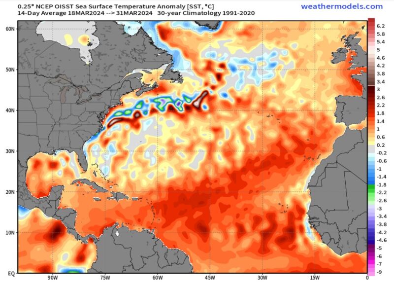
Klotzbach cites two major factors driving the busy year. The primary one is sea surface temperatures in the eastern and central Atlantic, where tropical systems develop. These seas are seeing record warm temperatures for April—indeed, in many places, the Atlantic is already as warm as it typically would be in June. Undoubtedly climate change is a central factor behind this warming.
Warm seas are one precursor to tropical systems, but they are just one condition necessary for a low-pressure system to organize into a tropical depression.
Another is low wind shear, as cross-directional winds can literally shear a storm apart. While it is not possible to forecast wind shear months ahead of a season, the presence of El Niño or La Niña in the Pacific Ocean is a pretty useful indicator.
In this case, there’s more bad news. The present (weak) El Niño in the Pacific is likely to transition into a La Niña by this summer, especially in August or September. That matters because these are typically the most frenetic months for activity, and with a La Niña in place, wind shear is likely to be lower overall in the Atlantic basin.
This is the first of several forecasts Klotzbach will issue for the upcoming season, and although predictions in April typically have lower skill, it is difficult to ignore the signals out there. “While the skill of this prediction is low, our confidence is higher than normal this year for an early April forecast given how hurricane-favorable the large-scale conditions appear to be,” he wrote.
What does this mean?
Most coastal areas along the Atlantic, Caribbean, and Gulf will not be affected by a hurricane in any given year. I live and work in Houston, which is the largest city in the Atlantic basin that regularly sees significant hurricane threats. But even here, in the subtropics, we only see large, direct impacts from a hurricane or tropical storm about every 10 years.
What a busy season does is load the dice. More activity means a greater likelihood that one of those storms will venture closer to where one lives. So the threat of a hurricane is there every year; it’s just that the threat is greater in some years.
There is an old, oft-repeated adage in hurricane forecasting circles: “It only takes one.” This means that even during a slow season if there’s just one hurricane and it hits you, it was a busy hurricane season for you. We experienced this in Houston back in 1983 when the very first named storm of the year, a hurricane named Alicia, made landfall near the city on August 17. There ended up being just four named storms in 1984, but unfortunately for Houston, one of them struck here.
A busy forecast like this doesn’t mean a whole lot for coastal residents. We really need to be prepared every year, knowing our vulnerabilities to a hurricane, knowing when we need to evacuate, where we would go, and what we would need to take.
However, it does have implications for first responders and government organizations tasked with dealing with hurricane aftermath, such as the Federal Emergency Management Agency. Thus, it seems prudent that the recently passed federal budget for fiscal year 2024 tucked $20.3 billion into the agency’s Disaster Relief Fund.


+ There are no comments
Add yours